Naming the Counties
By Glynda Pflug
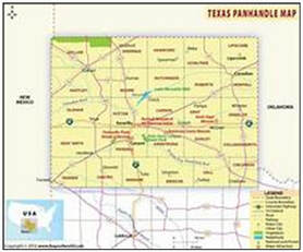
The changing shape of the Texas Panhandle has made for interesting maps and stories as to how the counties were named.
The final shape of the Panhandle was determined by the Compromised of 1850.
It is bounded on the east by the 100th meridian, on the north by parallel 36 degrees, 30 ft and on the west by the 103rd meridian. The southern boundary is aligned with the southern boundary of Swisher County.
In 1879, Wheeler County became the first organized county in the Panhandle with Donley County following in 1882. By 1891, the rest of the Panhandle was organized into counties with the exception of the Hutchinson in 1901 and finally, Gray in 1902.
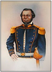 Commodore Moore
Moore County is located in the north central part of the Panhandle and is bordered by Sherman, Hutchinson, Potter, and Hartley counties and covers 900 square miles. Dumas is the county seat. Soon after Louis Dumas and The Panhandle Townsite Company founded the town in 1890, work began to organize the county. An election was held on July 5, 1892, and Dumas was named the county seat. The county was named for Commodore Edwin Ward Moore, a former commander of the Texas Navy. The City of Dumas was named after its founder, Louis Dumas.
Sherman County is directly north of Moore County. The county was organized in 1889 and was named for General Sidney Sherman, a veteran of the Civil War and the Texas Revolution and covers 923 square miles. In 1890, Coldwater, a small settlement near the center of the county, was named the original county seat. An election in May 1901, caused the county seat to be moved to Stratford. One of General Robert E. Lee's ancestral homes was called Stratford and that name was chosen for the Sherman County seat.
Sherman County is directly north of Moore County. The county was organized in 1889 and was named for General Sidney Sherman, a veteran of the Civil War and the Texas Revolution and covers 923 square miles. In 1890, Coldwater, a small settlement near the center of the county, was named the original county seat. An election in May 1901, caused the county seat to be moved to Stratford. One of General Robert E. Lee's ancestral homes was called Stratford and that name was chosen for the Sherman County seat.
Moore County is bordered on the east by Hutchinson County, one of the last Panhandle Counties to be organized. It was organized in 1901 and named for a pioneer jurist, Anderson Hutchinson. The county cover 871 square miles. The little settlement of Plemons was named county seat. A two-story court house and other buildings were erected, but in 1926, a special election caused the county seat to be moved to Stinnett and the small town of Plemons began to die. Stinnett was named for Albert Sidney Stinnett, a West Texas developer form Amarillo. He was instrumental in working with the Interstate Commerce Commission in Washington to get lower freight rates and service in the Panhandle. He and a partner plotted the townsite of Stinnett.
Hartley County borders Moore County on the west and was organized in 1891 with the town of Hartley as county seat. The town and county were named after Rufus K. and Oliver C. Hartley. An election in 1896 moved the county government to Channing, a smaller town south of the town of Hartley. Channing was founded in 1888 and was named for George Channing Rivers. Originally named Rivers, the town name had to be changed because of a conflict with another Texas town named Rivers. After several attempts to move the county seat again, a final election was held in 1903 and Channing remained the seat of the government. Hartley County is the largest of the surrounding counties with 1488 square miles.
Potter County on the south border of Moore County, comprises 902 square miles and was organized in 1887. The county was named for a colorful midshipman in the U. S. Navy and a member of legislature, Robert Potter, because of his service to the Republic of Texas. The county seat was originally calle Oneida and the town was often referred to as "The Yellow Rose of Texas." More than one story has developed as to how the name Amarillo was chosed, but probably the most accurate one has to do with the yellow color of the sub-soil in the Amarillo Creek. "Amarillo" is Spanish for "yellow." These five counties form the western hub of the Panhandle and through these counties, major north and south roads and railroads flow, bringing commerce and tourists through the Panhandle.